Unified EV charging map and elevation-aware route planner for Colombia
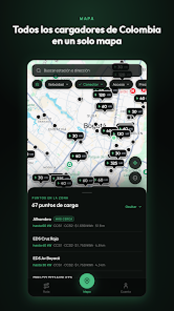
Aggregates public charging sites from more than 60 operators and plans routes that include compatible charging stops, factoring battery level and terrain elevation. Kallpa Map, from Kallpa Energy, is an Android map-GPS utility for Colombian electric vehicle owners and fleet managers. It shows connector types and kWh rates, reports real-time availability from operators and community updates, and exports locations to external GPS apps. The app suits drivers who need coordinated charger information on longer trips and in mountainous regions.
What the app does for EV travel and route planning
Kallpa Map consolidates scattered charger networks into a single navigation surface. It displays over 1,000 public connectors aggregated from more than 60 operators and builds routes that insert compatible charging stops based on current battery state and elevation data. The app exports station coordinates to external turn-by-turn navigation apps, letting drivers hand off to familiar GPS interfaces for the final leg.
How accurate and current the charger status is
Station availability combines operator feeds, field verification, and crowdsourced reports. Real-time status flags show occupied or out-of-service conditions, and users can submit updates that feed the community-led accuracy model. The presence of operator-provided data alongside manual checks gives a layered approach to availability reporting in a country with fragmented networks.
Device compatibility and how it connects to navigation tools
The app runs on Android and exports locations to external GPS apps. Users register their vehicle model so connector filters and range estimates match battery capacity. The app does not require device modification; it operates as a standard mobile map application and hands coordinates to other navigation apps for turn-by-turn directions.
Intended use cases, limits, and operator interactions
Designed for trip planning, fleet routing, and locating chargers rather than completing charging transactions. Detailed station profiles list kWh rates and operating hours, but in-app charging checkout isn't available; drivers complete charging through the operator's terminal or operator app. The elevation-aware routing addresses Colombia's terrain but cannot prevent operator-side outages or access restrictions.
Kallpa Map is a practical tool for Colombian EV drivers and fleets
The app is a focused option for drivers who need a single view of many independent charging networks and more realistic range estimates in mountainous routes. It concentrates on discovery, routing, and status reporting rather than handling charging sessions for you. Users who require consolidated station information and elevation-aware routing will find the app useful; those needing integrated charging checkout must use operator systems for the actual session.